Company Profile as of January 2020
Business Information:
- Business Name: EZ Surveying Co., Ltd. (EZS)
- Business Address: #12D Street Plov Lum, Sangkat Veal Spov, Khan Chbar Ampov, Phnom Penh, Cambodia
- Website: www.ez-surveying.com
- Facebook Page: www.facebook.com/ezsurveying
- Email: ezsurveying@gmail.com / info@ez-surveying.com
- Tel: +855 77 718 466 / +855 15 718 466
- Total number of employees: 10 (including full-time and project-based staff)
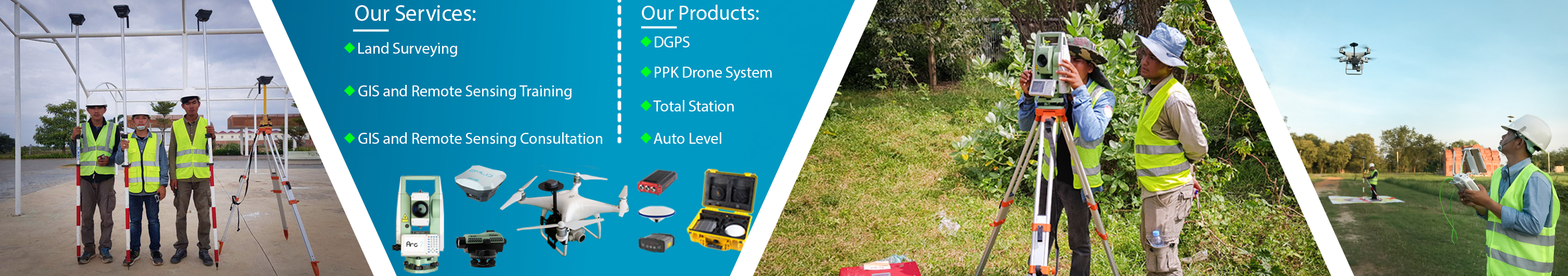
- Equipment we have: Auto Level, Total Station, DGPS, and Surveying Drones
Management Directory
- Mr. Veha La is the founder and currently the Managing Director of EZS.
- He graduated with a Master of Spatial Information Science from the University of Melbourne in 2013 and he has been working in the field Land Surveying, GIS (Spatial Database, Spatial Analysis, and Mapping) and Remote Sensing for over 10 years with projects implemented by UN agencies, INGO, humanitarian organization, consulting firm, and government ministry, in which he provided both services and training to project teams.
- Also, He has been a Freelance GIS Trainer with over 6 years of experience in designing GIS-related courses and providing training services to over 500 people from various backgrounds and organizations.
Company Overview
EZ Surveying Co., Ltd. was officially incorporated in 2017 but its management team has worked in these fields of expertise since 2008.
VISION
To be among the leading one-stop company providing services and products related to surveying, GIS and Remote Sensing works in the world.
MISSION
To provide affordable, reliable and efficient services and products related to surveying, GIS and Remote Sensing to clients in Cambodia and the world at large in a manner that satisfies our customers and delivers value for their money.
CORE VALUES
- Customer satisfaction is the reason for our existence.
- Our team spirit leads us to great strides in delivering timely solutions for our customers.
- Passion to serve thrives in our quest for greater heights in service delivery.
- Honesty and Integrity is our virtue.
- Exemplary service is our purpose in the industry.
QUALITY POLICY
EZ Surveying Co., Ltd. is a provider in all aspects of surveying, GIS and Remote Sensing. We are committed to consistently providing quality services and products that meet our customers’ requirements and other applicable requirements, to satisfy our customers and give value for money.
In pursuit of this commitment, we have established a Quality Management System in line with the requirements of ISO 9001:2008. We shall:
- Continually improve the effectiveness of the Quality Management System
- Establish, implement and review the quality objectives regularly.
- Build instructional capacity to continually improve the performance of the Quality Management Systems (QMS)
- Communicate the importance of meeting our customers’ requirements and the requirements of the QMS to all the employees.
- Ensure the policy is reviewed regularly for continued sustainability.
- Engage highly skilled human resource and
- Use effective communication between departments and with our customers.
General Business Activities
- Providing services:
- Land surveying with advanced and modern equipment such as Auto Level, Total Station, DGPS, and Surveying Drones
- GIS and Remote Sensing consultancy and training
- Selling products:
- Advanced and modern Land surveying equipment such as Auto Level, Total Station, DGPS, and Surveying Drones.
- Training and technical support are provided to the clients who bought the equipment from us.
List of Some Clients Who Bought Our Services and Products
|
Client Type |
Client Name |
|
Company |
|
|
Government |
|
|
I/NGO |
|
|
Individual |
|
List of Some Projects We Have Done (2016-2019)
|
No |
Project Description |
Location |
Client |
Equipment Used |
|
1 |
Surveyed land boundary for area of around 1 ha and stakeout the boundary points of the divided zones |
Phnom Penh |
Private |
DGPS |
|
2 |
Topographic survey of mountainous area for land size of around 25 ha to produce orthomap, elevation data, and contour maps |
Preah Sihanouk Province |
Private |
Drones and DGPS |
|
3 |
Surveyed land boundary and elevation data for calculating backfill volume for area of around 15 ha |
Phnom Penh |
Private |
DGPS |
|
4 |
Surveyed helipad site on top of a hospital building in Phnom Penh |
Phnom Penh |
Phnom Penh Medical Services Company Limited |
DGPS |
|
5 |
Topographic survey of Koh Pos island to produce orthomap, elevation data, and contour maps |
Preah Sihanouk Province |
Private |
Drones and DGPS |
|
6 |
Topographic survey along Riverside with length of around 5 km to produce orthomap, elevation data, and contour maps, and river embankment and depth survey |
Phnom Penh |
Standard Construction& Engineering Co., Ltd. |
Drones and DGPS |
|
7 |
Topographic survey of mountainous area of around 300 ha to produce orthomap, elevation data, and contour maps |
Preah Sihanouk Province |
Private |
Drones and DGPS |
|
8 |
Topographic survey of land area of around 25 ha on an island to produce orthomap, elevation data, and contour maps |
Preah Sihanouk Province |
Private |
Drones and DGPS |
|
9 |
Topographic survey of farmland for area of around 53 ha to produce orthomap, elevation data, and contour maps |
Kep Province |
Kampot Farm and Food Company., Ltd |
Drones and DGPS |
|
10 |
Stakeout land boundary points in Phnom Penh area for area of around 70 ha |
Phnom Penh |
Chu Yuan L2 (Cambodia) Development Co., Ltd. |
DGPS |
|
11 |
Topographic survey of farmland for area of around 280 ha to produce orthomap, elevation data, and contour maps |
Mondul Kiri Province |
Private |
Drones and DGPS |
|
12 |
Topographic survey to create elevation data for calculating backfill volume for area of around 60 ha, and created a network of three Benchmarks (BMs) |
Phnom Penh |
Gang Yuan (Cambodia) Development Co., Ltd. |
DGPS, Auto Level, and Total Station |
|
13 |
Topographic survey of an international school site for area of around 6 ha to produce orthomap, elevation data, and contour maps |
Phnom Penh |
The Room Design Studio Co., Ltd. |
Drones and DGPS |
|
14 |
Drone video filming along National Road No 5 with length of around 44 km |
Battambang Province |
Tekken - Ikee Joint Venture |
Drones |
|
15 |
Surveyed land boundary for area of around 60 ha |
Phnom Penh |
Gang Yuan (Cambodia) Development Co., Ltd. |
DGPS |
|
16 |
Topographic survey along Beach with length of around 3 km to produce orthomap, elevation data, and contour maps, and for calculating backfill volume |
Koh Kong Province |
Standard Construction& Engineering Co., Ltd. |
Drones and DGPS |
|
17 |
Topographic survey of farmland for area of around 300 ha to produce orthomap, elevation data, and contour maps |
Takeo Province |
Private |
Drones and DGPS |
|
18 |
Topographic survey of farmland for area of around 33 ha to produce orthomap, elevation data, and contour maps |
Kampong Speu Province |
HLH Agriculture (Cambodia) Co., Ltd. |
Drones and DGPS |
|
19 |
Drone survey along expressway PNP to SHV with length of around 190 km to create orthomap for creating GIS database and analysis for settlement and land use impact assessment |
Phnom Penh to Preah Sihanouk Province |
Ministry of Economy and Finance |
Drones and DGPS |
|
20 |
Stakeout around 400 points ad surveyed the points with Auto Level of Villa design and created a network of two Benchmarks (BMs) |
Phnom Penh |
Standard Construction& Engineering Co., Ltd. |
DGPS, Auto Level, and Total Station |
|
21 |
Drone survey along canal line with length of around 4.50 km to create orthomap for creating GIS database and analysis for railway settlement impact assessment |
Phnom Penh |
Standard Construction& Engineering Co., Ltd. |
Drones and DGPS |
|
22 |
Surveyed land boundary for area of around 15 ha, and created a network of three Benchmarks (BMs) |
Banteay Meanchey Province |
Private |
DGPS, Auto Level, and Total Station |
|
23 |
Topographic survey of farmland for area of around 130 ha to produce orthomap, elevation data, and contour maps |
Kampong Thom and Tboung Khmum Province |
Kamya Cambodian Eco-Farming Enterprise Co., Ltd. |
Drones and DGPS |
|
24 |
Topographic survey for area of around 780 ha to produce orthomap, elevation data, and contour maps |
Phnom Penh |
Private |
Drones and DGPS |
|
25 |
Topographic survey for area of around 550 ha to produce orthomap, elevation data, and contour maps |
Phnom Penh |
Private |
Drones and DGPS |
|
26 |
|
|
|
|
|
27 |
Topographic survey of farmland for area of around 280 ha to produce orthomap, elevation data, and contour maps |
Kandal Province |
Private |
Drones and DGPS |
|
28 |
Drone survey of Chbar Ampov Market area to create orthomap for accessing impact of fire incident |
Phnom Penh |
Private |
Drones and DGPS |
|
29 |
Surveyed land boundary for area of around 10 ha, and Topographic survey to produce orthomap, elevation data, and contour maps |
Preah Sihanouk Province |
Caffco International Development (Cambodia) Company Limited |
Drones, DGPS, and Total Station |
|
30 |
Topographic survey for area of around 190 ha to produce orthomap, elevation data, and contour maps and for calculating backfill volume |
Phnom Penh |
Standard Construction& Engineering Co., Ltd. |
Drones and DGPS |
|
31 |
Topographic survey of farmland for area of around 3,000 ha to produce orthomap, elevation data, and contour maps for master plan design |
Koh Kong Province |
Private |
Drones and DGPS |
|
32 |
Drone survey along canal line with length of around 3 km to create orthomap for creating GIS database and analysis for railway settlement impact assessment |
Phnom Penh |
Private |
Drones and DGPS |
|
33 |
Topographic survey along Beach with length of around 4 km to produce orthomap, elevation data, and contour maps, and river depth survey |
Preah Sihanouk Province |
Private |
Drones and DGPS |
|
34 |
Topographic survey of farmland for area of around 360 ha to produce orthomap, elevation data, and contour maps |
Ratanak Kiri Province |
Private |
Drones and DGPS |
|
35 |
Topographic survey of mountainous area of around 390 ha to produce orthomap, elevation data, and contour maps |
Kampot Province |
Private |
Drones and DGPS |
|
36 |
Topographic survey of Koh Tunsay island to produce orthomap, elevation data, and contour maps |
Kep Province |
Private |
Drones and DGPS |
|
37 |
Topographic survey of farmland for area of around 1,200 ha to produce orthomap, elevation data, and contour maps |
Kampong Speu Province |
Private |
Drones and DGPS |
|
38 |
Topographic survey of farmland for area of around 180 ha to produce orthomap, elevation data, and contour maps |
Siem Reap Province |
Private |
Drones and DGPS |
|
39 |
Topographic survey of farmland for area of around 2,800 ha to produce orthomap, elevation data, and contour maps |
Tboung Khmum Province |
Private |
Drones and DGPS |
|
40 |
Drone survey along railway with length of around 17 km to create orthomap for creating GIS database and analysis for railway settlement impact assessment |
Phnom Penh |
Ministry of Economy and Finance |
Drones and DGPS |