We can provide custom mapping services, generally with very short turnaround. After detailed mission planning (determining client parameters such as area to be covered, frequency of mapping, etc.), we fly the mission using whichever UAV type (fixed wing or multirotor) is appropriate for the location. Then we process the data according to client specification, including such details as:
Dense point cloud
High-resolution georectified orthomosaic
Elevation data (DSM or DTM, contour lines, XYZ CSV file)
3D textured mesh
Output to Global Mapper, ArcGIS, AutoCAD, etc.
Provide the map in printed, electronic or online format
Drone Mapping Applications
Surveying
Mapping
Mining
Forensics
Construction
Earthworks
BIM
Inspection
Agriculture
Real Estate
Descriptions of outputs from drone mapping
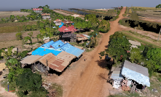
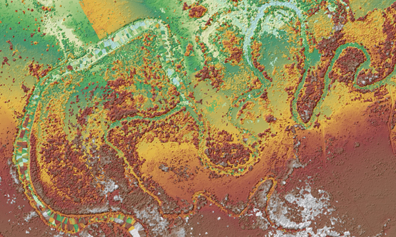
Dense Point Cloud
A point cloud is a set of data points in some coordinate system. In a three-dimensional coordinate system, these points are usually defined by X, Y, and Z coordinates, and often are intended to represent the external surface of an object.
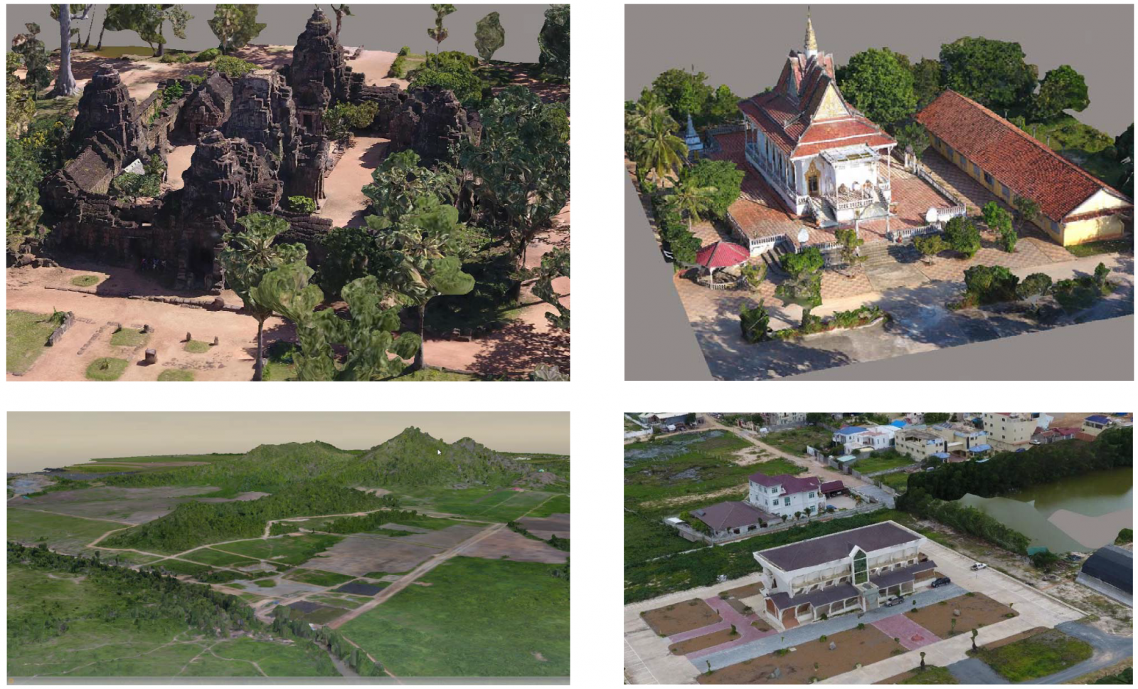
3D Textured Mesh
The 3D textured mesh is a representation of the shape of the model that consists of vertices, edges, faces and the texture from the images that is projected on it.
It is useful to present and visualize the model, share it and upload it to online platforms such as Sketchfab. It is intended to look nice more than to be accurate, so it is not recommended to use it for measurements.
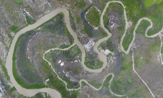
High-resolution Orthomosaic
An orthophoto or orthomosaic is an aerial photograph geometrically corrected (“orthorectified”) such that the scale is uniform: the photo(s) has the same lack of distortion as a map. Unlike an uncorrected aerial photograph, An orthophoto or orthomosaic can be used to measure true distances, because it is an accurate representation of the Earth’s surface, having been adjusted for topographic relief, lens distortion, and camera tilt.
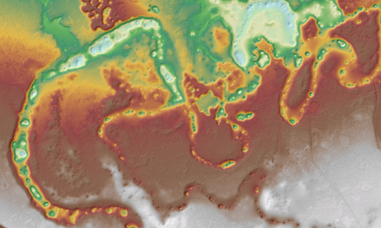
Digital Surface Models (DSM)
DSM's measure the height values of the first surface on the ground. This includes terrain features, buildings, vegetation and power lines etc. DSM's therefore provide a topographic model of the earth's surface. DSM's can be used to create 3D fly-throughs, support location-based systems and augmented simulated environments.
Digital Terrain Models (DTM)
DTM's provide a topographic model of the bare earth / underlying terrain of the earth's surface. They are usually derived from DSM's by digitally removing the cultural (man-made) and vegetation features.
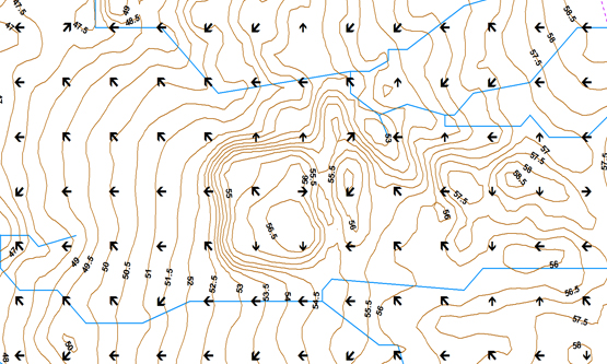
Contour Lines, Flow Direction Points, and Stream Network
This kind of data can be automatically extracted from DTM data by using GIS software such as ArcMap.
DRONE MAPPING
Now: $
We can provide custom mapping services, generally with very short turnaround. After detailed mission planning (determining client parameters such as area to be covered, frequency of mapping, etc.), we fly the mission using whichever UAV type (fixed wing or multirotor) is appropriate for the location. Then we process the data according to client specification, including such details as:
Dense point cloud
High-resolution georectified orthomosaic
Elevation data (DSM or DTM, contour lines, XYZ CSV file)
3D textured mesh
Output to Global Mapper, ArcGIS, AutoCAD, etc.
Provide the map in printed, electronic or online format
Drone Mapping Applications
Surveying
Mapping
Mining
Forensics
Construction
Earthworks
BIM
Inspection
Agriculture
Real Estate
Descriptions of outputs from drone mapping
Dense Point Cloud
A point cloud is a set of data points in some coordinate system. In a three-dimensional coordinate system, these points are usually defined by X, Y, and Z coordinates, and often are intended to represent the external surface of an object.
3D Textured Mesh
The 3D textured mesh is a representation of the shape of the model that consists of vertices, edges, faces and the texture from the images that is projected on it.
It is useful to present and visualize the model, share it and upload it to online platforms such as Sketchfab. It is intended to look nice more than to be accurate, so it is not recommended to use it for measurements.
High-resolution Orthomosaic
An orthophoto or orthomosaic is an aerial photograph geometrically corrected (“orthorectified”) such that the scale is uniform: the photo(s) has the same lack of distortion as a map. Unlike an uncorrected aerial photograph, An orthophoto or orthomosaic can be used to measure true distances, because it is an accurate representation of the Earth’s surface, having been adjusted for topographic relief, lens distortion, and camera tilt.
Digital Surface Models (DSM)
DSM's measure the height values of the first surface on the ground. This includes terrain features, buildings, vegetation and power lines etc. DSM's therefore provide a topographic model of the earth's surface. DSM's can be used to create 3D fly-throughs, support location-based systems and augmented simulated environments.
Digital Terrain Models (DTM)
DTM's provide a topographic model of the bare earth / underlying terrain of the earth's surface. They are usually derived from DSM's by digitally removing the cultural (man-made) and vegetation features.
Contour Lines, Flow Direction Points, and Stream Network
This kind of data can be automatically extracted from DTM data by using GIS software such as ArcMap.