GIS & RS CONSULTANCY
2017-07-05
GIS is a system for capturing, storing, analyzing and managing data and associated attributes which are spatially referenced to Earth, in other terms it is an information system capable of integrating, storing, analyzing, editing, sharing, and displaying information which is geographically referenced (establishing a relation between raster or vector images to map projections or coordinate systems). GIS is a tool that allows users to create interactive queries (user created searches), analyze the spatial information, edit data, maps, and present the results of all these operations.
Remote Sensing is the acquisition of information about an object or phenomenon without making physical contact with the object and thus in contrast to on-site observation. Remote Sensing is used in numerous fields, including geography, land surveying and most Earth Science disciplines (for example, hydrology, ecology , oceanography, glaciology, geology); it also has military, intelligence, commercial, economic, planning, and humanitarian applications.
Areas of work
- Geological Mapping
- Geomorphological Mapping
- Lineament interpretation and analysis
- Land Use Land Cover (LULC) extraction
- Digital Elevation Model (DEM) preparation using different types of satellite imageries
- Linear features mapping
- Mapping of two dimensional features like the polygon features
- Mapping of point features like the landmark features etc.
- Hydrological Mapping
- Thematic mapping of areas for facilitating for a better decision making
These outputs are used for working on assignments in sectors like hydro-electric project planning, Oil and gas sector, urban development projects, telecom projects (Digital map data for an area to plan a wireless telecommunication Radio Frequency or RF network which helps in studying the logistics of mobile usage and facilitate in planning network infrastructure), mining and mineral exploration, etc. ACE also works on projects like Vegetation Mapping, Forestry Mapping, Watershed Management, Gas Pipeline utility projects, Preparing GIS based geological database and Pipeline Utility Planning Feature extraction from different paper maps to convert into a digital format.
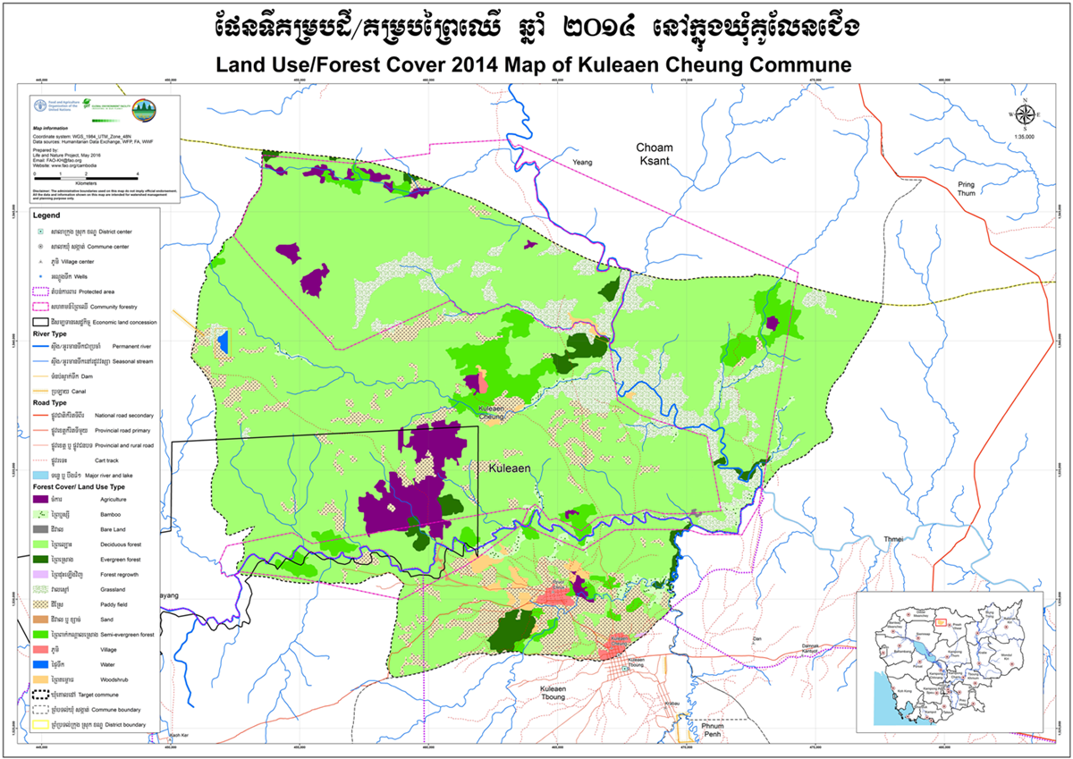
Sample map: Land Use/Forest Cover Map 2014 of Kuleaen Cheung Commune